Town Map
The Town Map (Japanese: タウンマップ Town Map) is a map device available in several core series Pokémon games. The version usable at the Pokégear is also referred to as Pokégear Map.
| |||||||||||||||
| |||||||||||||||
| |||||||||||||||

It is a Key Item in all Generation I games and their remakes, Pokémon Diamond, Pearl, and Platinum, all Generation V games, and Pokémon X and Y. There is also a Town Map on the wall in some buildings from Generation I onwards, in Pokémon Centers in Generations III and IV and in Pokémon: Let's Go, Pikachu! and Let's Go, Eevee!, as well as in gates in Pokémon Diamond, Pearl, Platinum, Brilliant Diamond, and Shining Pearl.
In some games, the Town Map is available by other means:
- In the Johto region, the player receives a Map Card after being given a tour of Cherrygrove City by the Guide Gent which allows the player to check the Town Map on the Pokégear.
- In the Hoenn region, the PokéNavRSE/PokéNav PlusORAS has a Town Map function.
- In the Sinnoh region, the Pokétch also has map-related functionality. In Generation VIII, the Town Map is part of the menu.
- In the Alola region, the Rotom Pokédex has a detailed Town Map for each of the four islands, as well as the exterior of Aether Paradise.
- In the Galar region, the Town Map is part of the menu.
- In the Hisui region, the Town Map is a function of the Arc Phone.
- In the Paldea region, the Town Map is a function of the Rotom Phone.
Terminology
The Japanese versions of Pokémon Red, Green, Blue, and Yellow included a physical poster with the map of Kanto, titled "Pocket Monsters Town Map".
In Pokémon Gold, Silver, Crystal, HeartGold, and SoulSilver, the map found at the Pokégear is named "Town Map" according to the Guide Gent in Cherrygrove City, some people who call the player through the Pokégear's phone, as well as in the quiz asked in the Goldenrod Radio Tower. It is named "Pokégear Map" by the character who welcomes the player into Kanto in Route 27.
In Pokémon Ruby, Sapphire, and Emerald, the map from the PokéNav is also seen at the wall in some buildings. This map seen in the building walls is referred to as a Town Map in Japanese, but it lost this name in the English localization, as seen below:
- Japanese: "<player>は ホウエンちほうの タウンマップに かおを ちかづけた!"
- Literal translation: "<player>'s face came closer to the Town Map of the Hoenn region."
- Localization: "<player> took a closer look at the Hoenn region map."
In Pokémon Omega Ruby and Alpha Sapphire, the PokéNav Plus's BuzzNav refers to the AreaNav map as a Town Map: "<Pokémon> checked a destination with <player> using the Town Map at... <location>."
In Pokémon Sun, Moon, Ultra Sun, and Ultra Moon, the detailed map from the Rotom Pokédex is named "Town Map" according to Professor Kukui.
In the core series games
Price
|
Effect
Generation I
In the Town Map, the player's current location is identified by the player's overworld sprite. It is also possible to select other places by using a blinking square cursor; this cursor selects the player's current place by default as well, but it can be controlled by pressing up or down. The name of the currently selected location appears at the top of the screen.
These are the normally selectable locations, which are scrolled through in this order: Pallet Town, Route 1, Viridian City, Route 2, Viridian Forest, Diglett's Cave, Pewter City, Route 3, Mt. Moon, Route 4, Cerulean City, Route 24, Route 25, Sea Cottage, Route 5, Route 6, Vermilion City, S.S. Anne, Route 9, Rock Tunnel, Route 10, Lavender Town, Pokémon Tower, Route 8, Route 7, Celadon City, Saffron City, Route 11, Route 12, Route 13, Route 14, Route 15, Route 16, Route 17, Route 18, Fuchsia City, Safari Zone, Sea Route 19, Seafoam Islands, Sea Route 20, Cinnabar Island, Sea Route 21, Route 22, Route 23, Victory Road, Indigo Plateau, and Power Plant.
These locations are only selectable when the player uses the Town Map while in this specific location, since the current location is displayed by default: Underground Path (Kanto Routes 5–6), Underground Path (Kanto Routes 7–8), Team Rocket Hideout (identified as "Rocket HQ" on the Town Map), Silph Co., Pokémon League, and Cerulean Cave. However, if the player moves the cursor around, these places will become unavailable on the map once more until the Town Map is used again.
No matter where the player is, either Route 1 or Power Plant will be selected at first when the player presses up or down, respectively.
Due to an oversight, if a player currently on Route 1 opens the Town Map, pressing up at first will apparently do nothing, as the selection will go from Route 1 (the current place) to Route 1 again. The player will need to press up twice to select the next place, which is Viridian City. Similarly, if the player is currently in the Power Plant, pressing down at first will apparently do nothing; they will need to press down twice to select the previous place, which is Indigo Plateau.
The place name displayed by default is Silph Co. if the player uses it anywhere in the company building, including in the elevator, except the place displayed is Saffron City if this item is used in the first floor of Silph Co. (except in the elevator).
The place name displayed by default is Indigo Plateau if the player uses it outdoors or in the lobby, but the place displayed is Pokémon League if the player uses it the rooms of the Elite Four, Champion, or Hall of Fame (even though items such as the Town Map are not usable in the Hall of Fame room, the place name is stored in the game data nonetheless).
Cerulean Cave is known by this name in the English version of the Town Map, but as ななしのどうくつ (Nameless Cave) in the Japanese version. This is referenced as the English game manual and some English official guides call it the Unknown Dungeon.
In this generation, the Japanese version of the Town Map has a limit of 9 characters for the displayed place name. This would be enough to display the full Japanese name of all the places available on the map other than Silph Co.. However, some words are not used on the Town Map: シティ (City), タウン (Town), しま (Island, as seen in Cinnabar Island), こうげん (Plateau, as seen in Indigo Plateau), and カンパニー (Company, as seen in Silph Co.). For instance, while the Town Map displays the full name "Cerulean City" in English, this place is displayed as ハナダ (Hanada) instead of ハナダシティ (Hanada City) in Japanese. Silph Co. is displayed on the Town Map as シルフほんしゃビル (Sylph Main Office Building), which may be a shortening of シルフ カンパニー ほんしゃ ビル (Sylph Company Main Office Building).

|

|
| The Kanto Map in Japanese Generation I games | The Kanto Map in international Generation I games |
Generation II

In Pokémon Gold, Silver, and Crystal, the Town Map is available as a Pokégear feature once the player has acquired the Map Card (Japanese: マップカード Map Card).
In this generation, the Town Map displays the map of the current region: Johto is available at first, and then later Kanto once the player enters that region. The squares representing towns and cities on the Town Map depend on the player's gender: orange for a boy, or blue for a girl.
The four images below display the Town Map without the Pokégear buttons, which is seen on the Pokédex Area screen.

|

|

|

|
| Johto Town Map (if the player is a boy) |
Kanto Town Map (if the player is a boy) |
Johto Town Map (if the player is a girl) |
Kanto Town Map (if the player is a girl) |
Generation III
Pokémon FireRed and LeafGreen
At first, the map will only display the Kanto region. During Generation III, after the player has ventured into the Sevii Islands, Celio will give them an upgraded map, featuring One, Two, and Three Islands. After entering the Hall of Fame and obtaining the National Pokédex, Celio will upgrade the map to its complete extent, revealing the final four Sevii Islands. The map display can be changed among the four sections (mainland Kanto; One, Two, and Three Island; Four and Five Island and Navel Rock; and Six, Seven, and Birth Island) at will after getting each new map.
Some locations have a guide (Japanese: ガイド guide) that details information on important places. This feature was expanded for every location on the Town Map starting in Pokémon Diamond and Pearl.

|
| The Kanto Map in FireRed and LeafGreen |
| Sevii Island Town Maps | ||
|---|---|---|

|

|

|
| One Island, Two Island, and Three Island | Four Island, Navel Rock, and Five Island | Seven Island, Six Island, and Birth Island |
Generation IV
Pokémon Diamond, Pearl, and Platinum
The Sinnoh Town Map offers flavor text descriptions of all visited locations in the game, and of all routes, visited or not. However, areas such as Fullmoon Island are not shown unless the player goes there. It resembles a Nintendo DS.
The Map is obtained in Jubilife City, when visiting the Trainers' School. The player receives it from their rival, Barry, upon giving him the Parcel from his mother.
Platinum's Town Map's location descriptions appear to have been taken directly from Pokémon Diamond and Pearl; for example, Route 212's description includes a reference to the house where shards can be traded for TMs, but in Platinum the TM-trading woman has been replaced by a Move Tutor.

|
| The Sinnoh Town Map |
Pokémon HeartGold and SoulSilver

In HeartGold and SoulSilver, much like in Generation II games, the Town Map is a Pokégear feature, and it is also seen on the wall of several buildings.
The mechanics of the map remain the same as in Generation II games, only to have several added features, including the ability to zoom in to display areas of interest, with certain locations having a small flavor text. There is another feature that allows the player to add notes and markings to different locations, to allow the player to make notes about each area about the Pokémon in the area, any Apricorn trees, any special buildings, TM locations or any other notes. These notes will appear on the top screen when the player highlights that specific area on the map. Like the Marking Map on the Pokétch, it also displays the current locations of all Roaming Pokémon, including Entei and Raikou.
If, in HeartGold and SoulSilver, a non-player character calls the player on the Pokégear phone for a rematch or to give an item, then the Pokégear map will display a small red exclamation point next to the name of the route or location.
Generation V

|

|
| The Unova Map in Black and White | The Unova Map in Black 2 and White 2 |
Generation VI
Pokémon X and Y

|
| The Kalos Town Map |
Generation VII
Pokémon Sun, Moon, Ultra Sun, and Ultra Moon

|

|
| The Alola Map in Sun and Moon | The Alola Map in Ultra Sun and Ultra Moon |
Pokémon: Let's Go, Pikachu! and Let's Go, Eevee!

|
This section is incomplete. Please feel free to edit this section to add missing information and complete it. Reason: Missing LGPE Town Map display |
Generation VIII
Pokémon Sword and Shield
In Pokémon Sword and Shield, the Town Map is available from the beginning of the game as part of the player's menu. In-universe, it is part of the player's Rotom Phone.
The player may press X to automatically move the cursor to their current location, Y to move the cursor to the location of their next objective (marked with a flag), plus (+) or minus (-) to toggle weather icons, and A to use the Flying Taxi if the cursor is currently over a reachable destination. The main Galar area, the Isle of Armor, and the Crown Tundra each have their own objective and pressing Y will correspond to the area the map is currently showing. If the player has fully completed the plot of one of these areas, there will be no objective location and pressing Y will have no effect.
An undocumented feature (not mentioned in the footer's button description) is that the player may press L or R to automatically move the cursor between cities/towns in story order, with R moving forwards and L moving backwards. This counts locations marked with a blue and yellow diamond on the map, meaning that Wyndon will appear twice (once for the main city and once for the Rose Tower/Battle Tower). When the map is opened, R will always point to Postwick and L will always point to Wyndon's tower, regardless of where the player's current location is. If the cursor is over the Isle of Armor or Crown Tundra, it will instantly move back to the main area upon pressing L or R.
When the player manually moves the cursor, it will snap to any nearby icon when it stops moving. For example, Route 2 initially counts as two icons (the "02" symbol partway along the route, and the dot in the middle of the lake marking the end of the route). After unlocking the Flying Taxi, the destination at Professor Magnolia's house becomes a third icon that the cursor will now snap to.
After visiting the Isle of Armor once, the player may scroll between it and the main Galar area on the map; the same applies to the Crown Tundra. However, the game will avoid straddling the boundary between the main Galar area and a DLC area. For example, placing the cursor over Postwick and scrolling down slightly will cause the map view to quickly move down a full screen, moving all of the main Galar area out of view (the map view will consist of only the top half of the Crown Tundra). The game will also avoid showing the blank ocean space north and south of the Isle of Armor. For example, if the cursor is at the very top of the map and the player scrolls right, the map view will quickly move diagonally downward to focus on the Isle of Armor. The player is not allowed to scroll north from the Isle of Armor. If the player scrolls south from the Isle of Armor, the map view will quickly move diagonally leftward at a shallow angle to focus on the Crown Tundra. The player is not allowed to scroll south from the Isle of Armor if they have never visited the Crown Tundra yet.

|

|
| Galar as seen in Pokémon Sword with the Expansion Pass (Version 1.3.0+) |
Galar as seen in Pokémon Shield (Version 1.1.1 or earlier) |
- Between Pokémon Sword and Pokémon Shield, the two version-exclusive Gyms show up in different colors on the map. From Version 1.2.0 onward, an extra set of train tracks and a train station are added to the main part of the Galar map leading to the Isle of Armor. From Version 1.3.0 onward, an additional set of train tracks are added leading to the Crown Tundra. These extra train tracks appear even if the player has not purchased the Pokémon Sword and Shield Expansion Pass.
- From Version 1.2.0 onward, at least the Isle of Armor is always present on the map even if the player has not purchased the Expansion Pass and therefore cannot scroll to it due to not having visited it yet. This is evidenced by the decorative island northwest of the Isle of Armor whose edge is barely visible when the view is focused on the main Galar area. The island did not exist on the map before the release of the Isle of Armor.
- A minuscule portion of the rightmost edge of the Frigid Sea is outside the bounds of the Crown Tundra map, and can only be briefly seen if the player has also visited the Isle of Armor and is scrolling between the two areas.
Pokémon Brilliant Diamond and Shining Pearl
In Pokémon Brilliant Diamond and Shining Pearl, the Town Map remains a menu option, and is no longer a Key Item like it is in Diamond, Pearl, and Platinum. It is still unlocked at the Trainers' School in Jubilife City.
The map has extra functions to view the location of Honey Trees, with blank trees identifying trees with no Honey, yellow trees identifying trees which are slathered with Honey, and glistening yellow trees when a tree is shaking. The map can also show the location of ripe Berries.

|
| The Sinnoh Town Map from Brilliant Diamond and Shining Pearl |
Description
|
Acquisition
|
Gallery
Sprites
| Gen III (FRLG/E) |
Gen IV-VI | Gen V obtain sprite |
BDSP menu icon |
In the anime
Main series
In Dreams by the Yard Full!, similar to Max with his PokéNav in Pokémon the Series: Ruby and Sapphire and Brock with his Pokégear in Pokémon the Series: Diamond and Pearl, Cilan is shown to have a Town Map for his journeys with Ash and Iris. It seems to have the ability to look up and locate various landmarks and natural occurrences as seen in Cottonee in Love! when Cilan uses it to track the flow of the wind, and in Facing Fear with Eyes Wide Open! when he locates plants used for an antidote for poison at the bottom of a lake.
In Best Wishes Until We Meet Again!, Cilan was seen examining the Town Map of Kanto and Johto while planning how he and Iris would continue traveling.
In A Battle of Aerial Mobility!, Clemont was revealed to own a Town Map.
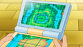
In Giving Chase at the Rhyhorn Race!, Serena was revealed to own a Town Map. Along with the map and current location shown on the left hand screen, the right hand screen can be used for a variety of other uses, including watching announcements for upcoming Pokémon Showcases by Monsieur Pierre. The device can also be used to search for information, as shown in Pokémon the Movie: Diancie and the Cocoon of Destruction where Serena used it to find out that Diancie could make diamonds.
Unova's Town Map
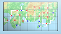
Kanto and Johto's Town Map
Kalos's Town Map


Pokémon Evolutions

A Town Map of Kanto appeared in The Discovery, under the ownership of Green.
In the manga

The Electric Tale of Pikachu
May Oak was seen giving Ash a Town Map in Pikachu, I See You!.
Pokémon Adventures
Diamond & Pearl arc
In this chapter, Pearl was often seen examining a Town Map.
Pokémon Zensho
In Pewter City, Daisy Oak gave Satoshi a Town Map, despite Shigeru having told her not to do so.
In the TCG

- Main article: Town Map (Boundaries Crossed 136)
Town Map was introduced as an Item card in the Pokémon Trading Card Game during the English Black & White Series (the Japanese BW Era). First released in the Japanese Freeze Bolt expansion, it later debuted in English in the Boundaries Crossed expansion, with both prints featuring an illustration by Toyste Beach. This Trainer card allows the player to flip their Prize cards face-up for the remainder of the game.
Trivia

- Before the release of Pokémon Gold and Silver, the only in-game source mentioning the name of the Kanto region was the Japanese-language text when examining the Town Map in Blue's house before the player obtains it.
In other languages
| |||||||||||||||||||||||||||||||||||||||||||
See also
- List of Key Items (Generation I)
- List of Key Items (Generation III)
- List of Key Items (Generation IV)
- List of Key Items (Generation V)
- List of Key Items (Generation VI)
- List of Key Items (Generation VII)
| |||||||
| This item article is part of Project ItemDex, a Bulbapedia project that aims to write comprehensive articles on all items. |